Secrets Underground
Beyond the township of Kurrajong, Bells Line of Road winds along an isolated ridge from Kurrajong Heights, through Bilpin, Berambing and Mt Tomah and on to Lithgow in NSW, Australia.
The area beyond Kurrajong was extremely remote in the 1800s and early 1900s. What induced settlers to come to this area in those early days? They left the support of their families, medical help, the police and schools; and faced all alone the dangers of drought, fires and accidents.
And when they did come, why did they only settle on just the narrow ridge where the road runs today, and on the isolated mountain tops of Mt Tomah and Mt Wilson? Why did they leave untouched hundreds of thousands of acres of the surrounding ridges and gullies of the Blue Mountains? The answer lies in the secrets underground...
|
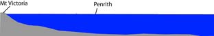
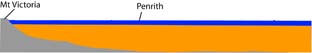
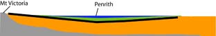
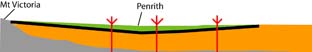
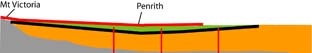
250 Million Years of Geological History in the Sydney Basin
|
|
Today we panic if global warming makes the sea rise one or two metres and begin washing away our houses. But 250 million years ago the sea level rose gradually to cover all the coastal areas right up to Lithgow! Fortunately for the environment though, it only rose very slowly, about 7 mm a year.
|
|
Then huge rivers from the west carried in sand sediments, laying down layer upon layer of sandstone that filled in the sea.
|
|
Eventually the sea became a shallow delta, and huge swampy forests and bogs developed. These compacted down to become the coal seams under Sydney today.
More sandstone was laid on top of the coal. Now the huge sea was reduced to shallow lakes, and muddy sediments in these lakes compacted down into layers of shale rock.
|
|
Finally 200 million years ago in the Age of Dinosaurs, isolated volcanoes exploded through the coal, sandstone and shale layers. Remains of about 95 volcanoes from this period have been found in the Sydney basin. There was even a volcano in Kurrajong called Diamond Hill!
|
Then about 14 - 20 million years ago there was another major volcanic event. A huge lava flow, 50 - 60 m thick, covered most of the Blue Mountains. Most this lava seems to have come from volcanoes or fissures in a single area but geologists have not been able to discover exactly where that was because all of the remnants eroded away long, long ago.
|
|
Finally the Blue Mountains were pushed up and the coastal sediments sagged, creating the eastern escarpment of the Blue Mountains. Rivers slowly cut deep gorges through the sandstone, coal shale and lava rock layers, gradually washing away immense volumes of rock (shown in brown on above diagram) and producing the Blue Mountains landscape of today.
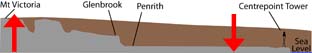
The huge lava sheet that once covered so much of the Blue Mountains was all eroded away except for little caps on high mountains such as Mt Tomah, Mt Wilson, Mt Banks and Mt Irvine. Can you imagine the huge amount of solid rock that was eroded away to achieve today's landscape?
|
The First Hidden Secret of the Blue Mountains: Volcanoes!
Volcanoes were the first hidden secret that influenced the pattern of settlement on Bells Line of Road. They poured out the immense lava flow that covered the mountains 14 - 20 million years ago, and blasted their way through the rocks 200 million years ago.
How can We Tell if a Particular Area had a Volcanic Past?
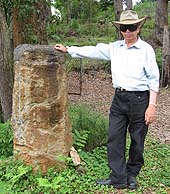
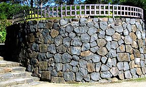
The lava from the volcanoes cools into a fine grained black rock called 'basalt'. As the basalt cools it may break up into spectacular hexagonal pillars. Mt Tomah is capped with a layer of 14 million year old basalt that is up to 140 m thick. Many columns and hexagonal blocks of basalt can be seen today at Mt Tomah. The Mt Tomah Botanical Gardens has built numerous feature walls from blocks of this basalt.
|
|
|
 |
Above left: Les Dollin with a hexagonal pillar of basalt at Mt Tomah; Left: top view of a basalt pillar with a near perfect hexagonal shape; Above: a wall at Mt Tomah Botanic Garden built from sections of basalt pillars. |
Basalt comes from molten rock that was originally about 2000 km underground. This black basalt rock weathers down into an extremely rich red soil. The red colour comes from its high iron content that oxidises to a rusty red colour. Most Australian soils lack phosphate. This is why we usually use so much superphosphate fertiliser for our crops. However, basalt soil contains a high level of natural calcium phosphate which acts like a fertiliser.
|
|
Deep rich red topsoil from weathered basalt at Mt Tomah |
The joints in the basalt rock also trap water that trickles out in springs. So basalt capped mountaintops like Mt Tomah and Mt Wilson have rich soil and plenty of water, growing massive trees and lush forests. With their cool climates, these mountaintops seemed like English gardens to the early settlers.
Mt Wilson supported a lush temperate rainforest of Blue Mountain Ash, Stringybark, Sassafras, Coachwood and Blackwood trees with huge tree ferns. Despite the remoteness of the area, settlers began to come to Mt Wilson in the 1860s and 1870s attracted to the fertility of this basalt mountaintop.
|
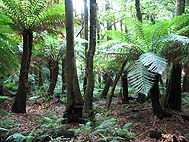
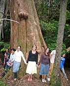
Left: a giant Brown Barrel Tree at Mt Wilson; Above: Lush ferny rainforest at Mt Wilson
|
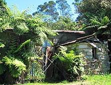
The fascinating history of Mt Wilson can be discovered today by visiting the Mt Wilson Museum, housed in the amazing Turkish Bath built by the Wynne family in the 1880s.
Kurrajong's Volcano, Diamond Hill
A Volcanic Diatreme
One of the isolated volcanoes that blasted through the Sydney Basin bedrock 200 million years ago was at Kurrajong. Known today as Diamond Hill, this low grassy hilltop is only three km from Kurrajong.
Diamond Hill was a type of volcano called a 'diatreme'. Molten rock forced its way up through a weakness in the rock from deep underground. The 1000 oC molten rock hit water near the surface and superheated it, resulting in a massive explosion. This blasted out a wide cone of the surrounding sandstone and shale rock. The fragmented rock eventually compacted back down into the crater forming a rock called 'breccia'. Later more molten rock sometimes forced its way up through the breccia, filling part of the crater with lava that cooled into 'basalt'.
Twenty diatremes are found in the Penrith region at locations such as Diamond Hill, The Bull Ridge (East Kurrajong), Tennyson, Valley Heights, Marsden Park and Blacktown. Studies of spores and pollen embedded in the rocks suggest that these volcanic diatremes were active in the Jurassic age, about 200 million years ago.
Diatremes contain much smaller pockets of volcanic rock than the broad lava caps on Mt Wilson and Mt Tomah. However, they can still weather down into localised deposits of rich volcanic soil that support lush vegetation. Diatremes may also attract the interest of mining companies, keen to quarry the deposits of breccia and basalt for crushed rock and road base.
The Second Hidden Secret of the Blue Mountains: Shale!
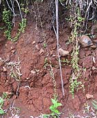
As previously mentioned, a band of shale rock was laid down in the Sydney Basin about 200 million years ago. This shale came from fine clay particles that settled out in shallow lakes, compacting down into a layered grey-coloured rock.
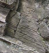 |
Layers of shale rock in a road cutting near Mt Tomah on Bells Line of Road |
Shale weathers into a fertile clay-rich soil that retains water and is good for growing forests and crops. Shale soil is not as fertile as volcanic soil because it lacks the phosphorus. However, it is still is much richer than soils that come from sandstone
There is quite a lot of shale in the Kurrajong area and this supported the orchard industry of Kurrajong's early years. A narrow band of shale is also found right along the crest of the ridge where Bells Line of Road runs today, from Kurrajong Heights, through Bilpin and Berambing. This shale with its heavy forests of timber was what attracted settlers to the remote Bells Line of Road area in the late 1800s and early 1900s.
Ken and May Hungerford came up to remote Berambing in 1916 and operated a saw mill there for many years. In their home, 'Sookaboomi', Ken and May raised a son and four daughters. Their youngest daughter, Hesba Brinsmead, became a prizewinning novelist. Her fascinating books, Longtime Passing, Longtime Dreaming, Christmas at Longtime and Once There was a Swagman, tell stories from her family's experiences living in Berambing and Mt Tomah in the early 1900s.
|
|
Sookaboomi homestead, built by the Hungerford family in about 1917 on their shale soil property at Berambing
|
Conclusion
So we return again to our questions:
-- What attracted settlers to come to the remote areas along Bells Line of Road?
and
-- Why did the pioneers settle along the narrow ridge of Bells Line of Road, and at Mt Tomah and Mt Wilson, but not on the surrounding thousands of hectares of the vast Blue Mountains?
The secrets underground provide the answer: the rich basalt soils on Mt Tomah and Mt Wilson, and the fertile shale soils along the crest of the ridge at Bells Line of Road, attracted our early settlers to just these limited areas. The underground basalt and shale are two hidden secrets of the Blue Mountains that attracted settlers to our region.
By Anne Dollin
Disclaimer: Whilst I have taken all care in assembling the material in this article from texts and scientific papers, my scientific training was not in geology.
Further Reading
DC Jones and NR Clark (eds) (1991). Geology of the Penrith 1:100,000 sheet 9030. 201 pp. NSW Geological Survey, Sydney.
J Pickett (1987). Geology. In: The Mt Tomah Book. The Mt Tomah Society and The Royal Botanic Gardens Sydney.
P Van der Beek, A Pulford and J Braun (2001). Cenozoic landscape development in the Blue Mountains (SE Australia): lithological and tectonic controls on rifted margin morphology. The Journal of Geology 109: 35-56.
| The above article is based on a presentation Anne Dollin gave to the Kurrajong Comleroy Historical Society on their field trip, Hidden Secrets of the Blue Mountains.
On this field trip on 11 March 2008, 52 members and guests of the Society visited the rich basalt cap at Mt Wilson and the Mt Wilson Museum; Kurrajong's own volcano, Diamond Hill; and the Hungerford family's homestead, 'Sookaboomi', on the shale soils of Berambing.
|
|
|